All features need to be traced from a copy of the original map (a tracing, photocopy or photograph) on to a computer. It isn’t possible to work from the original because they are far too large (up to 8 feet in length and width) and fragile (in some cases very fragile).
The area covered by the map needs to be located on the modern map so that the image or the tracing being worked from can be related to the real world. This is done using any surviving features from the original map still visible on the modern map such as road junctions or field boundaries. Where no features are visible then early edition Ordnance Survey maps are used.
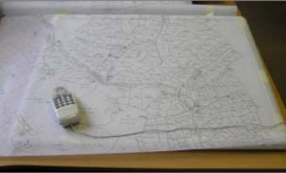
Every detail is then traced from the original map on to a Geographical Information System using a digitising tablet (as shown below, with a tracing of a map) or, if using a digital photograph, the PC’s mouse. The map features are then coded by type (e.g. for buildings, water, roads etc.) so that they can be displayed differently depending on what the feature is (e.g. roads are coloured grey).
All features are then numbered to allow features on the map to be linked to data from the database.
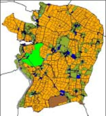
Once the data is loaded, and has been checked for duplicate or missing entries, the GIS can then be used to its full potential and the map can be coloured by landowner, land use or tenant with a legend to show the values from the database (e.g. all arable land is orange).
Where information is not recorded on the original map or documentation no value will exist in the database. Land use is not always recorded on inclosure maps, for example.