Parish
Assessment Number
975
National Archives Field Book Reference
IR58/93299
Date Inspected
9 Jan 1915
Present-day Address or Approximate Location
10 Pitchers Hill
Property description
Description
House & Agricultural Land
Estimated Extent
1a 0r 20p
Interest of Owner
Freehold
Situation
Pitchers Hill
Particulars
Ordnance No 14. Land and detached cottage about 20 years old, brick and tile with recent additions. Heavy clay land on high site with Prolifics and Victorias; iron rails on east side and 10 ? on west side against occupation road. 3 bedrooms, sitting-room, back kitchen, kitchen, pantry, earth closet and coals with bathroom recently added and water supply.
Occupier, owner and rent details
Occupier's name
Miss EMPEYOwner's Name
George Compton LEES-MILNEAddress of Owner (as in Valuation Book or Provisional Valuation)
The Manor, Wickhamford
Rent Amount
£20
Occupier's Tenancy - Term
Yearly
Date of former sales (prior to Lady Day 1909) and cost
23 Nov 1908 - £36 8s (subsequent expenditure: £99 17s 8d)
Valuation details
| Gross Value (amount which the land might be expected to make on the open market, free of any encumbrances) | £432 |
|---|---|
| Full Site Value (amount which remained after deducting the value of the buildings, etc, from the gross value of the land) | £102 |
| Total Value (gross value, with deductions made for any fixed charges, rights of way and rights of common) | £400 |
| Assessable Site Value | £70 |
| Deductions for buildings and structures (when working out the full site value) | £285 |
| Deductions for fruit trees (when working out the full site value) | £40 |
| Deductions for other things growing or on the land (when working out the full site value) | £5 |
| Deductions made for fixed charges, etc (when working out the Total Value) | £330 |
| Deductions made for things such as easements, tithes, public rights of way when arriving at market value | £32 (tithes) |
Provisional valuation and sale details
Provisional Valuation Date Confirmed
Not served 19/4/1915
Additional information
Land Valuation Survey Maps
Views maps (E&F)
Photos of the property
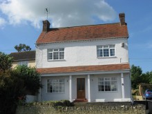
2015 photo